
What are the best hikes in the UK?
Sometimes it helps to get a look at your country through a visitor’s eyes. We reached out to some of the most travelled bloggers and writers on their choice for our list of best UK hikes.
Some old favourites came up, of course, but also a handful of ones we hadn’t even heard of. If you’re looking for new challenges to topple this hiking season, check out the list below and see which hikes have woo’ed our visitors over the years.
1. Striding Edge, Hellvelyn
Chris from Global Shenanigans
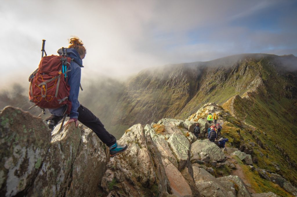
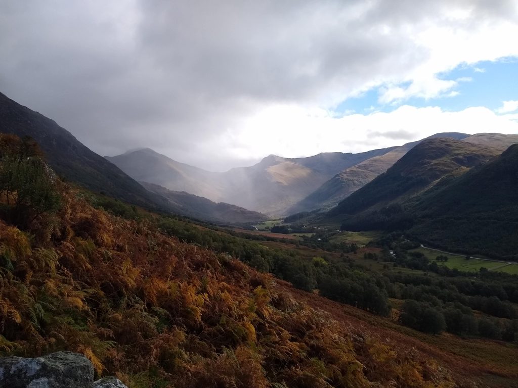
One of my all time favourite hikes in the UK is Striding Edge, the scrambly ridge line that leads up to Hellvelyn. Helvellyn is a mountain located in the endlessly wonderful Lake District. This area has hikes available for all difficulties through its rolling hills and jagged peaks.
Striding Edge is a favourite for me due to the sheer epic beauty of the jutting rock. This is the reason it has become one of the top hikes in all of the UK. The path there begins in the village of Glenridding. You begin on a mellow wind through the village and slowly up beside a forest and lake. Head onwards until you eventually make it to the crest of the hill and get eyes on Helvellyn. Things start to get scrambly from, as you start to depend on your hands just as much as your feet.
On one side of the ridgeline has enough width that even a novice climber can rise to the challenge without too much fear of exposure. There’s a few metres clearance on either side, before it drops to a steep valley on your left, and down to a lake on your right.
Enjoy the ride and remember to take plenty of photos!
Parking can be found at Ullswater Information Centre.
2. Baslow & Curbar Edge – Peak District
Jenny from Peak District Kids
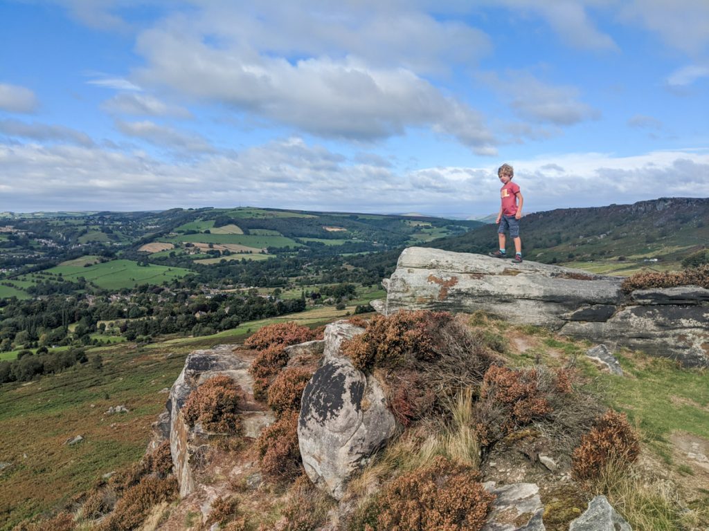
Standing on Baslow Edge on a clear day you can see the grand estate of Chatsworth House to the left and then the famous Kinder Plateau in the far distance to the right. Plus, this is often where you’ll see the characterful Highland Coos of the Peak District.
There’s a short Baslow Edge walk (2.7km) that leads you along the dramatic escarpment to to Wellington’s Monument (a gritstone cross dedicated to the Duke of Wellington for his victory in the Battle of Waterloo in 1815) and then back to the starting point via Eagle Stone (which looks more like a frog than an eagle).
However, straight across the road is then Curbar Edge. You can continue walking along the next escarpment, which is equally dramatic, which leads onto Frogatt Edge. Stop for a chip butty and pint or Peak Ale at The Grouse Inn, before looping around along White Edge and back to the starting point.
Combining Baslow Edge walk and the Curbar Edge walk is 12km and one of the best walks in the Peak District. With a stop at the pub, allow a good 4-5 hours. Also, it gets very windy up on the escarpments and the temperature is always a degree or two colder, so take an extra layer with you.
There is no public transport to get here. You need to have your own wheels.
3. Cheddar Gorge and the West Mendip Way
Suzanne from Meandering Wild
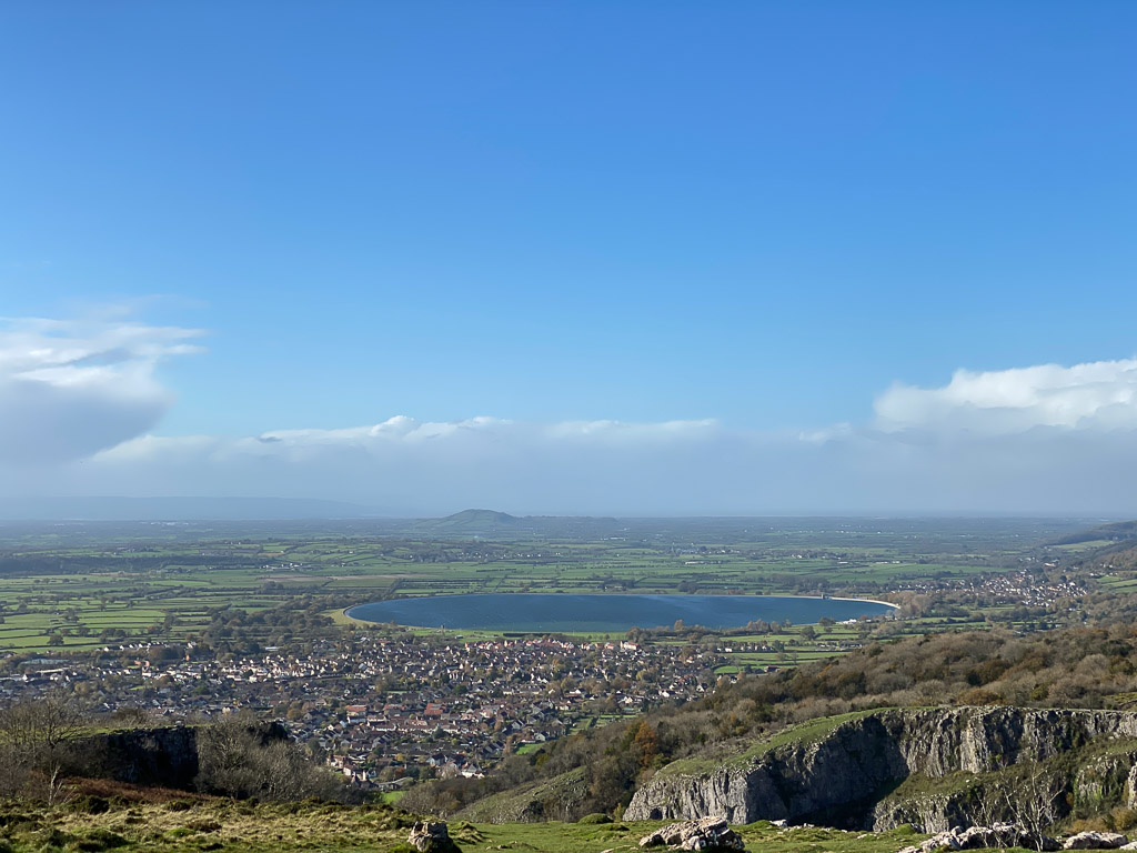
Cheddar Gorge is located in Somerset in the south west of England. It is the deepest gorge in England and has high cliffs that tower over the narrow road that winds its way up to the top of the Mendip Hills.
The hike starts in the small village of Cheddar. This is well known for its cave systems that disappear under the hills that the hike follows. The hike is a circular route of just over 7km, but can be extended by following the well marked West Mendip Way that this loop is part of. The West Mendip Way is an 80km route running from Weston-super-Mare to Frome.
The first few kilometres are steep and uphill through woodland, but eventually you come out onto open grassland that runs along the top of the gorge cliffs. This area makes the hike as the views on a good day are across the Somerset Levels to Glastonbury Tor and across the Bristol Channel to South Wales. If you are feeling brave there are lookout points that allow you to look down on the road running through the gorge itself. While it is not a remote hike it can feel a million miles from the village below.
Cheddar is about 3 hours from London. By road it is off junction 22 of the M5 and then just a short drive up the A38. Getting to Cheddar by public transport is a little more difficult and involves a train to Bristol and then a bus to Wells and a second bus to Cheddar.
Looking to revamp your gear this hiking season? Check out our buyers guides for hiking leggings and hiking boots.
4. Arthur’s Seat
Maria from Maptrekking
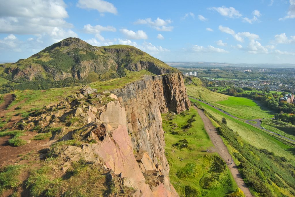
If you are traveling the UK and planning to visit Scotland’s capital, hiking Arthur’s Seat is a must. Located in Holyrood Park in the city centre of Edinburgh, Arthur’s Seat is an extinct volcano that has breathtaking 360-degree views of the North Sea, the Pentland Hills, Holyrood Palace, and Edinburgh Castle. Most Edinburgh travel guides will point you to this popular hiking trail, and for good reason too. From the city, you can see people at the summit at all times of the day and even in the worst weather.
The reason why I love this hike is that it provides an easy and quick way to escape from the city into nature. The whole of Holyrood park is a small snapshot of the stunning landscape found in the Scottish highlands. Usually, the hike is about 30 minutes but make sure to take your time to enjoy what is around you. There are multiple ways to hike up to Arthur’s Seat summit through the park, which is great because it gives you the chance to explore the glens, basalt cliffs, 2 natural springs, and 3 lochs.
If you are looking to visit, it is an easy 4-hour train journey from London to Edinburgh Waverley train station. Since Arthur’s Seat sticks out of the middle of the city like a sore thumb, it will be hard to miss it. The two main starting points that are usually taken are near Holyrood Palace & St. Margaret’s Lock and then one behind Pollock Halls Residence.
5. Scafell Pike
Demi from Around The World With Her
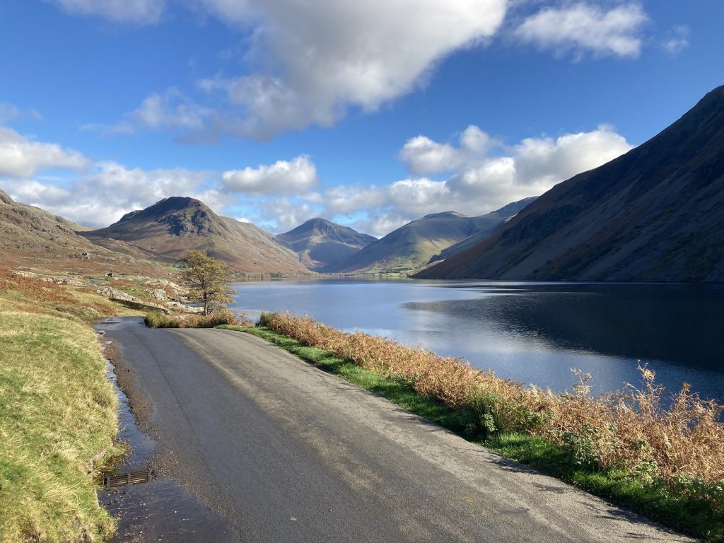
When it comes to the best hikes in the UK, not many compare to Scafell Pike. The mountain is set in the amazing scenery of the Lake District, a UNESCO world heritage site. Scafell Pike is the tallest mountain in England, and also overlooks the deepest lake in England – Wastwater. There are several routes up to the summit, of varying lengths and for different abilities. Visitors tend to stay in nearby quaint villages or towns like Keswick or Ambleside.
The most popular route to the summit is the shortest. This route starts at the head of stunning Wastwater, where there is a car park, campsite and small visitor centre. The hike takes around 4 – 6 hours as a round trip to reach the summit, depending on your speed. The summit is 978m above sea level, and on a clear day you can see across the Lake District and even over to the Isle of Man
Whilst you do not need to be a professional mountaineer to tackle Scafell, do not underestimate the climb. The route is gentle and easy to navigate for the first section. However as you near the summit, it becomes much more like a scramble up screes. Be aware that cloud an cover the summit quickly, and temperatures at the top can be a lot lower than below. Come equipped, and be prepared to enjoy one of the UKs best hikes!
6. Broxbourne Woods
Annabel from Smudged Postcard

Broxbourne Woods is the only national nature reserve in Hertfordshire. Located within day trip distance of London, the woods can be accessed on foot from Bayford railway station (one mile) which is 40 minutes from Finsbury Park. The reserve is made up of four separate woodlands: Broxbourne, Bencroft, Hoddesdonpark and Wormley.
Hikes at Broxbourne Woods National Nature Reserve are fairly flat and take visitors through stretches of ancient woodland containing hornbeam and oak trees. There are also sections of pine which were planted for timber and are slowly being replaced with native species. The reserve is an important habitat for wildlife. There are routes of varying lengths so it is perfect for hikers of all ages and abilities. The main trail is 18km which traces a rough figure of eight meaning you can choose to walk just one loop or both.
A highlight of the Broxbourne National Nature Reserve is the Broxbourne Sculpture Trail, a one kilometre circular trail with sculptures by Daniel Cordell. The sculptures are mostly carved by wood using a chainsaw although there is one distinctive metal sculpture of a stag which surveys walkers from its almost camouflaged position.
In you are in need of refreshments, there are some excellent country pubs close to Broxbourne Woods.
7. Hole of Horcum – North York Moors
Maja from Away With Maja

One of the best hikes in the UK is the Hole of Horcum in the North York Moors National Park.
The traditional starting point for the walk is the Saltergate car park off the A169, but you can also start the walk in the village of Levisham (and enjoy a pint at the Horseshoe Inn at the end!)
The hike is a circular loop and easy to follow, taking you along the top of the moors, through woodland, and eventually through the bottom of the hole. The walk is approximately 5 miles and should take between 2 ½ and 3 hours. The Hole of Horcum itself is approximately ¾ of a mile across, and 400 feet deep.
While it’s a fantastic hike year-round, the best time to visit the Hole of Horcum is at the end of August, when the heather blooms and blankets the moors in purple flowers.
It’s easiest to do the hike if you have a car, but it’s possible to do the hike with public transportation. From Leeds or York (both of which have frequent, direct trains to London), take the 840 Coastliner bus out towards Whitby—there is a bus stop near the Saltergate car park. Alternatively, from Pickering you can take the heritage North Yorkshire Moors Railway to Levisham, and then start the walk from Levisham station. Don’t miss hiking the Hole of Horcum on a visit to Yorkshire!
8. Valley Of The Rocks
Lauren from The Planet Edit
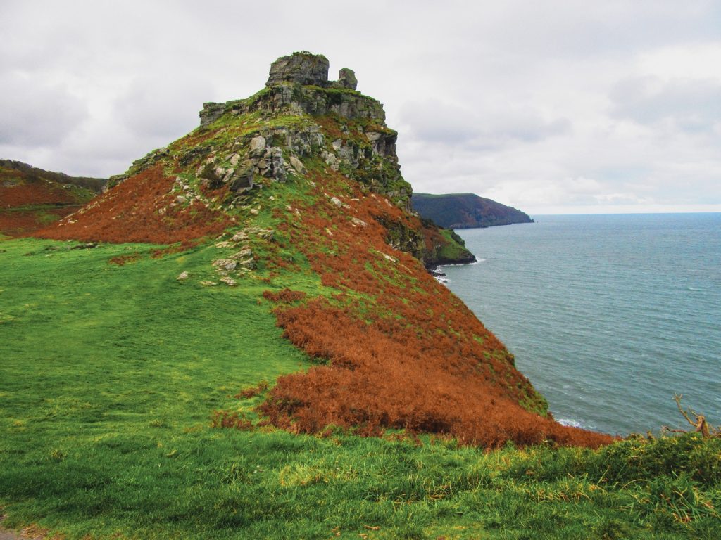
Located in the Exmoor National Park on the north coast of Devon, you’ll find the Valley of the Rocks, a picturesque outcrop where imposing towers of rock pepper the skyline.
Carved out of the earth by thousands of years of erosion by the East Lyn River and the unrelenting Bristol Channel, these impressive rock formations sit among the highest coastal cliffs in Britain. The highest formation of them all – Castle Rock – is much like a fortress; tall and mysterious, it offers breath-taking views across the sea.
I absolutely adored my hike through the Valley of the Rocks. It follows the Tarka Trail, part of Britain’s famous South West Coastal Path. The walk is not particularly challenging, yet still provides some truly epic scenery and is, in my opinion, one of the best short hikes in the UK.
Keep your eyes peeled as you walk, as you might just spot a few feral goats scaling the steep slopes of the valley. Goats have been present in the valley for hundreds of years, and the herd is periodically repopulated, as they assist in maintaining plant biodiversity in the area thanks to their grazing habits. And, if you’re particularly lucky, you might even see some of Exmoor’s semi-wild native ponies.
How to get to Valley of the Rocks?
The trailhead to Valley of the Rocks is located in Lynton – a small town within the Exmoor National Park on the North Coast of Devon. Minehead and Barnstaple are the largest nearby towns, both of which have roads leading directly to Lynton. Using a car is by far the easiest way of getting there, although taking a train to Barnstaple and then a bus to Lynton is also possible.
Prevent blisters this hiking season. We round up the top selling hiking boots and hiking socks this year.
9. Mam Tor
Pauline from Bee Loved City
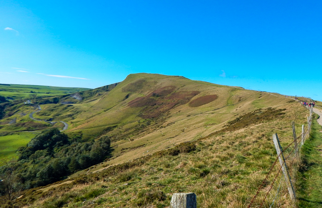
Located between Manchester and Sheffield, Peak District National Park is home to some of the best hikes in the UK. The most famous one is Mam Tor.
To get there, you can either drive or take a train from Manchester to Edale, the nearest village.
The quickest way to get to the top is from the National Trust car park. Head towards the back and you will find the steps. It only takes 30 minutes and is a great short hike for families. Once you get to the summit, you will discover fantastic 360 degree views of the valleys and national park.
From there, you can either make your way back the way you came or keep going to Hollins Cross before turning left to head back down.
If you want to go on a more adventurous hike, opt for the circular walk from Castleton to Mam Tor via the Great Ridge. This 9-mile hike is one of the best ridge walks in Europe. It will take you about 5 hours to complete it. From Castleton, walk through Cave Dale and make your way to the Mam Tor car park. You will then start the way up to the summit. Instead of turning left at Hollins Cross, keep going on the ridge until you reach Back Tor and Lose Hill.
You will then start walking down, back to Castleton.
Mam Tor is ideally located in the heart of Peak District. It boasts the most amazing views in the national park and there are many hiking trails in the area. Watching the sunrise from there is also an incredible experience and one of the reasons why it became so popular.
10. Durdle Door – Jurassic Coast
Angela from The Life Of Spicers
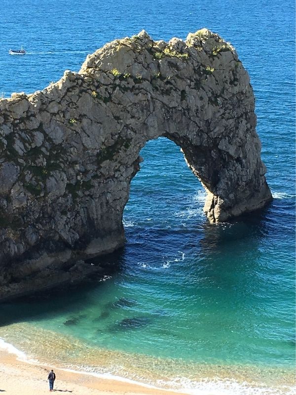
Durdle Door is a section of the Jurassic Coast in Dorset. Famously known for the natural limestone arch that attracts thousands of visitors every year.
There are plenty of hikes near Durdle Door, all of which provide stunning views from the paths and cliffs around.
Durdle Door is a good starting point for hikes as there is a convenient, large car park in Durdle Door holiday park (BH20 5PU), which is located right on the South West Coastal Path. Also on site are public toilets and a refreshment van, perfect for fueling you at the beginning or the end of your hikes.
The most popular route, and possibly my favourite is the walk between Durdle Door and Lulworth Cove. This is just over a mile in distance one way, and whilst it provides those stunning views, there are also inclines and descents to navigate.
If you’re looking for a more challenging walk, then some of the more challenging hills can be found hiking out of Durdle Door towards Ringstead Bay. This hike is both challenging and rewarding, but I would suggest walking poles are a must along this stretch of the Jurassic Coast.
A great place to relax at the end of your hike is on Man O War beach near the famous arch. Sit back and soak up the brilliant views.
11. Ben Nevis
Josh and Sarah from Veggie Vagabonds
“If you’re looking for the best hike in the UK, the most obvious choice has to be the biggest, right?
Ben Nevis is the tallest peak in the UK and the hike to its summit is absolutely awesome. Though there are many Ben Nevis hiking routes to the top, for your average hiker the mountain track is best advised. This is a there-and-back route, roughly 11 miles long and should take you 6-8 hours. It’s quite a long day and you gain about 1,145m of altitude so it’s best taken on by people with moderate fitness or hiking experience.
The track itself takes you through awesome highland landscapes and from the top, the views are nothing short of sensational. It really should be high up on your bucket list!
This hike is best attempted late spring through to early autumn. Into the winter you’ll get some pretty harsh mountain conditions and it shouldn’t be attempted by people without winter skills.
To get to the trail, there’s easy access from Fort William, which is very well connected by train to London and other UK cities. From Fort William, you can walk to the trailhead (2 miles or get a local bus).
Thanks to it being so beautiful, it does get quite a lot of traffic, so best to avoid weekends and holidays too!”
12. Blencathra, Lake District
Paul from Anywhere We Roam
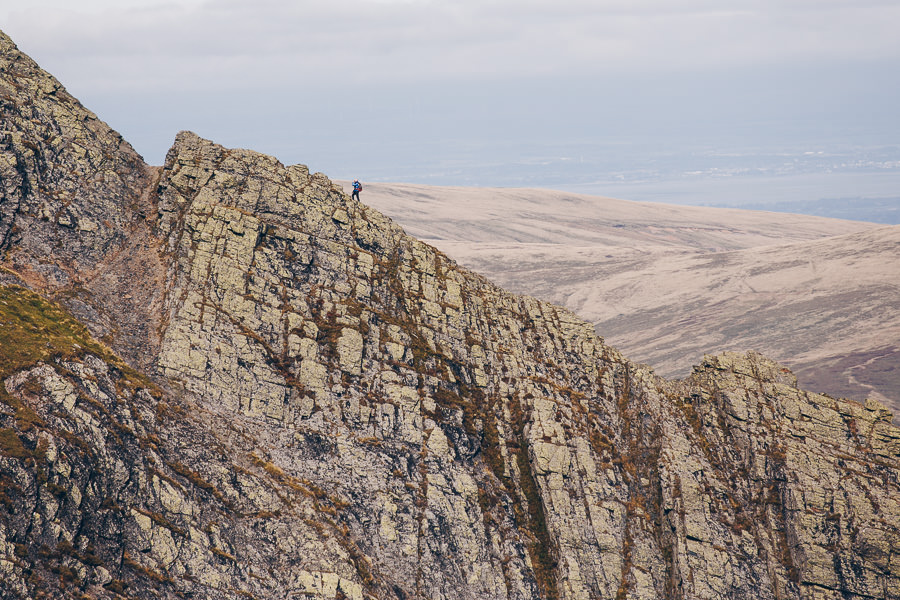
Blencathra is a mountain in the Lake District which provides the setting for one of the best hikes in the UK. The views from the summit are sensational with the northern peaks of the lakes arrayed in geometric succession with picturesque tarns breaking up the vista.
However, it’s the ascent up Sharp Edge that makes this walk so unique. As the most exposed grade 1 scramble in the Lake District – Sharp Edge is a knife edge ridge that requires nerves of steel, a head for heights and steady hands and feet. The ridge is only a couple of hundred meters long, but it’s extremely narrow and exposed with vertical drops on either side. Around two-thirds of the way along there is a ‘bad’ step that requires shuffling on your backside along a sloping slab of rock and down onto a narrow edge. It’s not pleasant, but it definitely gets the adrenaline pumping.
The descent is via Halls Fell Ridge. This is a much wider and less exposed ridge where you can enjoy the challenge of the scramble without thinking too carefully about every footstep or handhold. It’s also an opportunity to enjoy the impressive Lake District views.
To get to the Blencathra walk from London, take the train to Penrith station (5 hours). From Penrith it’s a 20-minute drive to Scales for the start of the trailhead. This allows you to do the ascent via either Hall Fell Ridge or Sharp Edge.
13. National Forest Way
Karen from Marvelous Middle England
The National Forest Way in the Midlands is a 75 mile trail connecting Staffordshire to Leicestershire. Created in 2014, the National Forest Way took a full four years to finish and was designed to encourage more people to enjoy the National Forest. It’s now one of the most popular long distance hikes in the UK. The forest is stunning in all seasons making this a good hike to complete year round. I particularly like forest bathing in Autumn as the leaves turn vibrant shades of red, russet and orange.
The whole route should take around a week to complete, giving you plenty of time to explore the beautiful Midlands Countryside. You’ll be hiking through ancient and new forest, across rolling green fields and up forgiving peaks. Much of the hike explores old mining land which has been reclaimed and redeveloped into woodland available for all to enjoy the great outdoors.
None of the route is too challenging but is definitely a long distance. If you would like to split it in easier chunks, the Way can be broken down into 12 stages. Each of which can be accomplished in one day ranging from four to seven and a half miles.
The Way can be completed East to West or West to East. If you begin in the West, your starting point will be at the National Memorial Arboretum in Alrewas, Staffordshire. If you’re planning on hiking the full way it’s best to be dropped off here or take public transport as you may struggle to find long term parking. You’ll want the number 12 bus from Lichfield which is easily reached by train from Birmingham New Street. Birmingham is just an hour and a half from central London by train.
Always take a paper map when you’re completing a trail, phone signal is not guaranteed. This can be downloaded from the National Forest Website.
14. New Forest
Mal from Raw Mal Roams

If you’re looking for some great hikes in an area of outstanding beauty, then you will love The New Forest. This National Park is situated mostly in Hampshire and covers a vast area of woodlands and pasture fields. The most incredible thing about the New Forest is that it is habited by beautiful ponies that live freely within the borders of the park. In the spring you can see their cute baby ponies which is often the highlight of the forest hikes.
There is a lot of hiking routes to choose from varying in length and difficulty. Try a 14 km long trail through Hollands Wood in Brockenhurst to Lyndhurst. Another good one is Solent Way and in particular its Lymington to Beaulieu part. Make sure you check out the capital of the New Forest – Lyndhurst, which is a charming town in the heart of the forest. Try one of their traditional tea rooms for a delicious cream tea or locally produced ice cream. Lyndhurst is also an excellent base to stay a few nights if you’re planning a longer trip.
The New Forest can be a great day trip from London by train. It will take just under 2 hours starting from Waterloo and the closest station to the park is Brockenhurst.
15. Symonds Yat – Wye Valley
RJ from RJ On Tour

Symonds Yat is a beautiful part of the country on the England/Wales border and is a great spot for hiking. The village of Symonds Yat East is located in the Wye Valley AONB, a woodland gorge with many trails through it. The riverside hikes are the most popular often passing Biblins Footbridge, a great spot for views of the area.
One of the lesser walked paths is from the Forest of Dean village of Staunton. This takes you near to the unmanaged Lady Park Wood, which is a great place to see wildlife, in particular deer and birds of prey.
Starting at Staunton it is all downhill until you hit the river at Biblins Bridge. Hikers then can choose which side of the river to reach the Symonds Yat East. Symonds Yat is a nice place to stop for refreshments at the local pub The Saracens head. From here there are options, upstream to Lydbrook and beyond, downstream towards Monmouth or the steep path to the viewpoint. The viewpoint provides a spectacular view of the Wye valley on a clear day.
Getting to the Wye Valley AONB from London involves car or by train and local busses. The two options for those coming by rail are Gloucester or Lydney stations then navigate the local bus routes to your chosen hiking route.
16. Whinlatter Forest Hike
Daniel from Urban Abroad
When on the lookout for some of the best hikes in the UK and happen to find yourself in the Lake District, one of our favorites was at Whinlatter Forest.
It is no secret that the Lake District has many hikes to offer, however, in Whinlatter Forest you’ll find a myriad of off the beaten path tracks and trails suited to all kinds of hikes and difficulty levels. There are currently 9 walking trails and 2 running trails that you can choose from. Whinlatter also has on-site parking (for a small fee) so you can drive directly to the venue, and if you fancy a detour there are other interesting places to visit and a nearby village for a traditional pub lunch after your hike.
Our morning consisted of a full two hours of walking the Seat How Summit trail which in total covers 3.5 miles and is elevated in many parts so be sure to get your fitness levels up to a decent standard. There any various upland fells such as Darling How, Broom Fell, and Lords Seat which offer spectacular viewpoints and are always a great reward once you have arrived at the top.
All in all, Whinlatter Forest offers many great hikes and the beautiful woodland scenery gives you the opportunity to get away from your everyday life and breath in some crisp fresh air. There is a café and a visitor center on-site for those who choose to skip a visit to the nearby village but fancy a bite to eat or snack afterwards.
17. Camel Trail
Georgina from Culinary Travels

The 18 mile Camel Trail is a picturesque hike – taking the route of a disused railway line once used by the London and South West Railway, the trail follows the Camel Estuary from Padstow to Wadebridge before joining the route through the deep and beautifully wooded Camel Valley to Bodmin.
Set off from the pretty riverside town of Wadebridge and the coast-hugging section of the trail is a much more manageable six-mile walk. This area is pretty much flat, making it much more family-friendly as it is easier on little legs too. You could alternatively take (or hire) your bikes along and attempt the complete stretch. Whatever the weather it is a beautiful area to explore.
18. Mourne Mountains
Allan from It’s Sometimes Sunny In Bangor
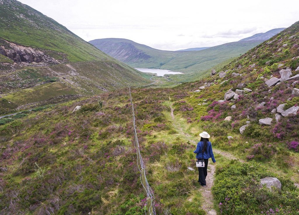
When it comes to hiking in Northern Ireland, few places can compare to the majestic Mourne Mountains, a designated Area of Outstanding Natural Beauty found out in County Down. The Mournes are a rather expansive mountain range with a diverse area including many standalone attractions such as the woodland treks of Tollymore Forest Park, and the gardens of Castlewellan. The main hike however would be to Slieve Donard, the highest peak in Northern Ireland with an elevation of 850 metres. This would be a moderate hike, and while it is steep in parts, it is otherwise generally doable given a basic level of fitness. The peak is also easy to access following a direct trek from the seaside town of Newcastle where there is also a large car park at the foot of the climb and it’s simple to find from the main stations of the town. If more flexible with transport however, there are many alternative routes and points of entry to the Mournes, and one of the more popular hikes would be from the Silent Valley to Ben Crom Reservoir, an area renowned for the sheer beauty and views over the reservoir from above. This trek would also be fairly flat and simple, but there are always opportunities to go off track and to explore the surrounding peaks in the area.
19. White Cliffs Of Dover
Sophie from We Dream Of Travel
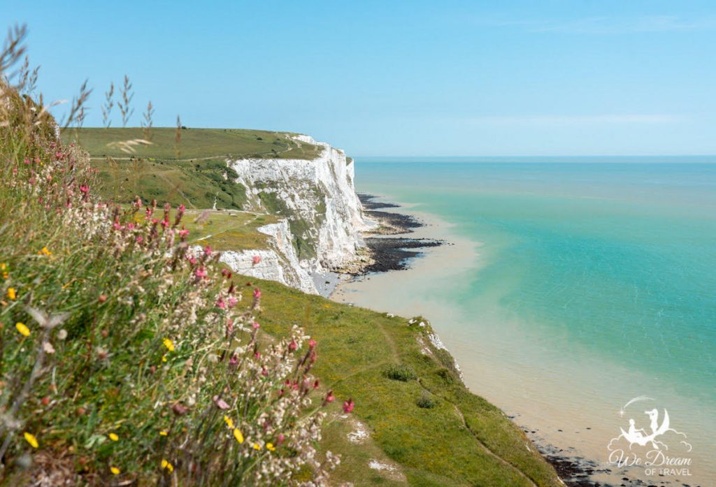
Stretching over 16 miles along the south coast of England, the White Cliffs of Dover offer a number of beautiful hiking trails just waiting to be explored. Standing at an impressive 350ft above sea level, a walk along the chalk grassland atop these giants provides breathtaking views over the vibrant blue waters of the English Channel. On a clear day, you can even see as far as France!
The most popular is the South Foreland Lighthouse trail. This easy 4-mile return hike provides a scenic route from the National Trust car park to the South Foreland Lighthouse. Traverse across the cliffs, past grazing ponies and field of wild flowers. At South Foreland Lighthouse, you’ll find a tearoom to stop at. However, it’s well worth continuing on beyond the lighthouse to St Margaret’s Bay, where you can stop at the local pub for a pint or, if you’re brave enough, take a dip in the sea! If you add St Margaret’s Bay then the total hike is approximately 6-mile return.
You can escape the hustle and bustle of the city and take a day trip to the White Cliffs of Dover from London easily by train or car. If you have more time, there are also several other longer walks you can take from Dover. The South Foreland trail comprises part of two longer walks; the England Coast Path (2795 miles) and the Saxon Shoreway (160 miles).
Looking for local hikes? Check out our picks for top hikes in and around London.